
Welcome! We invite you to register.

Trekking
Tenerife is a true paradise for hikers. The island boasts a stunning diversity of landscapes, and in a matter of kilometers, you can go from walking through humid, verdant forests to crossing volcanic trails that look almost Martian. The king, of course, is Mount Teide: climbing Spain's highest peak is a unique experience, with views that seem straight out of another planet. However, you need to plan your trip well because you need a permit to reach the summit, although just walking its trails will give you a sense of the volcano's power. In the north, the Anaga Biosphere Reserve is a world away. There, the paths disappear into laurel forests, ravines, and viewpoints with breathtaking views of the sea. It's the perfect place for fresher, greener routes and to discover small, hidden hamlets that seem frozen in time. If you're looking for something different, in Teno, you'll find trails that cross rugged mountains and spectacular cliffs, such as the famous descent to Masca, which combines wild nature with the reward of reaching the sea. And on the coast, there are gentler trails alongside natural pools and lagoons, ideal for combining hiking and swimming. The best thing is that Tenerife offers options for everyone: from easy hikes to enjoy with the family to long and challenging routes for the more adventurous. With each trail, the island changes face, and this variety means there's always a new corner to discover. In short, trekking in Tenerife isn't just a sport: it's the most authentic way to experience the island, to connect with its nature, and to discover corners that would go unnoticed by car. Each route is a surprise, and the difficult part isn't finding one, but deciding which one to start with.
Montaña Tejina
Guia de Isora
Distance :
If you enjoy less crowded hiking in southern Tenerife, this circular route around Montaña de Tejina is a very complete option. You'll walk approximately 13 km around this large volcanic crag, over a thousand meters high, which was a sacred site and key center of social interaction for the Guanches. The route passes through ravines, ancient threshing floors, small hermitages, and traditional agricultural remains. There's hardly any shade, but in return, you'll have open panoramic views for much of the way and a constant sense of a rural, volcanic, and mystical landscape.

El Tomadero
Punta del Hidalgo
Distance :
A circular route in Anaga Rural Park connecting Punta del Hidalgo with El Tomadero, ascending via a channel carved into the rock and descending through the ravine. It's approximately 6 km with little elevation gain, but includes technical and exposed sections that increase the difficulty. The channel is in very good condition and clean, although it can be quite vertigo-inducing in some places. The descent through the ravine is rocky and uncomfortable. A short but demanding route, not recommended for people with vertigo.

Ruta del Trillo
Fasnia
Distance :
The Threshing Route, in La Zarza (Fasnia), is a circular ethnographic trail that pays homage to cereal farming and the small farmers who worked these lands in difficult times. A peaceful walk among threshing floors, traditional terraces, and open mid-altitude landscapes, it's ideal for discovering the agricultural past of southeastern Tenerife.

PR TF 06
Mazico de Anaga
Distance :
This trail is no walk in the park: it's Anaga in its purest form. You hike the PR-TF 6 knowing that steep inclines, rough terrain, and plenty of sun await you. It connects El Draguillo, Chamorga, and the Anaga Lighthouse, passing through isolated hamlets and along a wild coastline. Here, every step demands attention, but in return, you'll walk one of the most complete and challenging routes in the massif, with breathtaking scenery, rich history, and genuine silence.

Sendero Montaña Roja
El Medano
Distance :
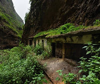
Walking the circular route that starts in El Médano and heads toward Montaña Roja is like stepping into an otherworldly volcanic landscape: reddish sand, deep blue sea, and the wind that caresses you with every step. You can see World War II bunkers, aquatic birds, and panoramic views of the southern part of the island. You'll love it if you're looking for an easy hike with that "reconnect with nature" feel in southern Tenerife.

Sendero Los Catalanes
Mazico de Anaga
Distance :
The Los Catalanes Trail, in the Anaga Mountains, combines rural history and spectacular landscapes. It's a medium-difficulty route that connects old farmhouses through terraced fields, laurel forest, and sea views. The contrast between the humid vegetation and the remains of traditional Canarian life make this route an authentic experience, highly representative of the greenest and most peaceful side of Tenerife.

Sendero Charca de Tahodio
Santa Cruz
Distance :
The Charca de Tahodio trail in Santa Cruz de Tenerife is one of the closest routes to the city and, at the same time, one of the quietest. It connects the Valleseco neighborhood with a reservoir surrounded by green mountains, offering an unexpectedly natural landscape just minutes from the urban hustle and bustle. Ideal for a relaxing walk, it combines ocean views, monteverde vegetation, and the calm of the reservoir water.

Sendero Barranco del Rio
Arico
Distance :
The Barranco del Río Trail, in Arico, is one of the most surprising routes in southern Tenerife. It traverses a deep ravine with natural pools, waterfalls, and rock formations eroded by centuries of water and wind. It's an adventure trail, ideal for those who enjoy hiking among wild landscapes and natural contrasts, with stretches of lush vegetation that recall the island's most secret side.

Sendero de Los Organos
La Orotava
Distance :
The Los Órganos Trail, in the Corona Forestal Natural Park, is one of the most iconic routes in La Orotava. It passes through a thick, beautiful pine forest to reach the impressive basalt cliffs reminiscent of organ pipes, formed by volcanic action. With views of the Orotava Valley and Mount Teide, it is an ideal hike for nature lovers and those who enjoy peaceful hiking.

Sendero Montaña de Chayofita
Los Cristianos
Distance :
The Chayofita Mountain Trail in Los Cristianos is a simple, short route that offers one of the best panoramic views of southern Tenerife. Its route, just over a kilometer long, gently climbs an ancient volcanic cone to a peak overlooking Los Cristianos, Las Américas, and the Atlantic. It's ideal for a sunset walk, enjoying the tranquility and the cityscape from above.

El Batan
Mazico de Anaga
Distance :
The El Batán trail, in the heart of the Anaga Mountains, is an experience that combines nature and tradition. The route descends through lush laurel forests to the hamlet, one of the most isolated on the island, where the rural Canarian life of yesteryear can still be felt. It's a route that impresses with its green landscapes, tranquility, and direct contact with Tenerife's traditional culture.

El Sauzal - Fuente del Pino
El Sauzal
Distance :
The route connecting El Sauzal with Fuente del Pino in La Matanza is a local trail, ideal for enjoying the tranquility of northern Tenerife. It runs through vineyards, ravines, and small rural roads, with views of the sea and Mount Teide. It's a relatively simple but charming route that combines nature and tradition, as the fountain was historically a meeting place for shepherds and neighbors.

El Sombrero de Chasna
Vilaflor
Distance :
The Sombrero de Chasna Route is a trail that leads to one of the most iconic mountains in southern Tenerife, renowned for its distinctive profile. From its summit, you can enjoy breathtaking panoramic views of Mount Teide, the Ucanca Valley, and the southern coast. It is a high-mountain route that combines history, volcanic landscapes, and the pastoral traditions that shaped life on these peaks.

Tunel de las Hadas
Mazico de Anaga
Distance :
This circular route from Pico del Inglés combines the mysticism of the Fairy Tunnel, a natural pass surrounded by dense vegetation and frequent fog, with the rural charm of Roque Negro. The route offers laurel forest landscapes, natural viewpoints, and sections that seem straight out of a fairy tale. It's an ideal trail for those seeking a visually magical experience deeply connected to the nature of Anaga.

Samara
Parque nacional del Teide
Distance :
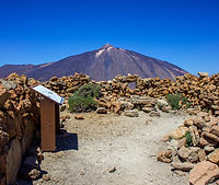
The PNT 13 Sámara Circular Trail traverses a unique volcanic landscape within Teide National Park, with constant views of the majestic peak. The route passes through lava fields, pine forests, and volcanic cones, offering an immersive experience in the geology and nature of Tenerife's high mountains. It is an accessible and visually stunning route, ideal for those seeking direct contact with the island's volcanic history.

Roque de Taborno
Mazico de Anaga
Distance :
The Roque de Taborno is an imposing rock formation that crowns the hamlet of Taborno, in the heart of Anaga Rural Park. Its circular trail offers breathtaking views of cliffs, ravines, and the Atlantic Ocean, in a setting where laurel forest blends with rugged landscapes. It's a spectacular spot for hikers and lovers of unique panoramas.

Malpais de Guimar
Güímar
Distance :
The Malpaís de Güímar is a nature reserve that protects a unique volcanic landscape on the east coast of Tenerife. Its trails run through lava fields, volcanic cones, and areas of tabaiba and cardon ferns, offering a spectacular contrast with the intense blue of the Atlantic. It's an ideal place for leisurely walks, birdwatching, and photographing a nearly untouched environment, where nature is revealed in its purest state.

Punta Rasca
El Palmar
Distance :
The El Palm-Mar to Punta de Rasca trail runs along the southern coast of Tenerife, crossing a volcanic and semi-desert landscape with uninterrupted views of the Atlantic. Along the way, you can spot dolphins and, occasionally, sea turtles from the cliffs and high points. The route culminates at the Punta de Rasca lighthouse, a secluded and photogenic spot where the sea crashes forcefully against black rocks and unique coastal formations.

Montaña de Guaza
Arona
Distance :
Guaza Mountain, in southern Tenerife, is a protected natural area that connects Los Cristianos with El Palmar via a coastal and high-altitude trail. The trail offers spectacular views of the Atlantic and, from several points, the chance to spot dolphins and sea turtles in the nearby waters. It is a place where the volcanic landscape, marine wildlife, and tranquility combine for a unique experience.

Roque del Conde
Adeje
Distance :
Roque del Conde is an imposing volcanic plateau located in southern Tenerife, recognizable by its flat peak that rises above Adeje and Arona. The climb offers one of the most sweeping panoramic views of the island, from Mount Teide to La Gomera. With Guanche legends tied to its history, it is a place that combines challenging hiking, volcanic landscapes, and a unique connection with Tenerife's ancestral roots.

Circular Caserio de Teno Alto
Parque Rural del Teno
Distance :
A leisurely hike through the picturesque village of Teno Alto, in one of Tenerife's most rural and authentic corners. Ideal for those seeking traditional landscapes, rural Canarian architecture, and a close encounter with country life.

Paisaje Lunar
VilaFlor de Chasna
Distance :
This route is very popular for its unique landscape of volcanic rock formations in the form of cones and chimneys, known as the Lunar Landscape. It starts in Vilaflor, the highest village in Spain, and runs through Canary Island pine forests, lava, and volcanic ash. Ideal for geology enthusiasts and photogenic hikers.

Circular Afur - Taganana
Mazico de Anaga
Distance :
This circular route from Afur to Taganana is a gem of Anaga Rural Park. It crosses the Afur ravine to Tamadite beach, follows the cliff-lined coast to Taganana, and returns along a trail that climbs through forest and mountains. Wild landscapes, a contrast between sea and mountains, and a very authentic rural atmosphere. Good physical fitness and suitable footwear are required.

Pico Viejo
Parque nacional del Teide
Distance :
The Pico Viejo circular hike offers a unique experience through the lunar landscapes of Teide National Park. Starting in Las Cañadas, it ascends along volcanic trails to reach the summit of Pico Viejo (3,135 m), the second highest point in the Canary Islands. The views of Teide, the crater at over 800 meters, and the neighboring islands are spectacular. Good physical condition and preparation are required.

Pico del Teide
Parque nacional del Teide
Distance :
The Montaña Blanca route to Teide is the most iconic and challenging route to reach Spain's highest peak, at 3,718 m. It traverses a unique volcanic landscape, passing through the Huevos del Teide and the Altavista Refuge. Good physical condition and an official permit are required to reach the summit. An unforgettable experience for those seeking adventure and pure nature.

Barranco de Badajoz
Güímar
Distance :
The Badajoz Ravine, also known as Chamoco, is a volcanic canyon in Güímar, surrounded by lush vegetation and steeped in indigenous history and mystery. It houses 19th-century water galleries and the Cañizo Cave, used by the Guanches. Recognized as a trail steeped in legend, its atmosphere combines landscape, archaeology, and the inexplicable.
Circular las Raices
La Esperanza
Distance :
This refreshing circular trail (approximately 5 km) starts and returns to the Las Raíces recreational area, crossing a Canary Island pine forest with shaded sections and views of the Güímar Valley. Ideal for a gentle family walk, with benches, good signage, and a peaceful atmosphere surrounded by nature.
Circular de Agua Garcia
Tacoronte
Distance :
The Agua García Trail surrounds the mountain of the same name in Tacoronte, offering a circular walk among centuries-old viñátigos, laurel forests, and natural springs. Ideal for families or seniors: easy access, rest areas, and a cool, quiet environment where the perfect balance of nature and local history emerges.

Cruz del Carmen - Punta de Hidalgo
Mazico de Anaga
Distance :
This trail descends from the laurel forest in Cruz del Carmen to the Atlantic coast at Punta del Hidalgo. Over its 12 km, it passes through foggy areas, traditional hamlets, and deep ravines. It is a challenging but unforgettable route that connects the mountains to the sea through the green heart of Anaga.

Charcas de Erjos
Parque Rural del Teno
Distance :
The Charcas de Erjos are natural pools hidden in a volcanic setting, surrounded by vegetation and wildlife. From Erjos Square, you can walk along an ancient path to these pools, ideal for birdwatching and photographing in a secluded and peaceful setting. Perfect for a hassle-free family outing.

Bosque de los Enigmas
Mazico de Anaga
Distance :
A 5km circular trail in the heart of Anaga's laurel forest, ideal for those who want to walk surrounded by mist, moss-covered trees, and green mystery. It features interpretive panels with natural "enigmas," is accessible, well-marked, and can be completed in less than two hours. Perfect for families, beginners, or those curious about the enchanted forest.

Sendero Roques de Garcia
Parque nacional del Teide
Distance :
The Roques de García trail is a 3.5-km circuit next to the iconic Roque Cinchado. You'll walk among unique volcanic formations such as La Catedral and El Burro, with Mount Teide always in the background. It's the perfect way to enjoy the scenery effortlessly, take stunning photos, and experience volcanoes at ground level.

Alto de Guajara
Parque nacional del Teide
Distance :
The Alto de Guajara trail begins at Degollada de Guajara and climbs approximately 2 km to 2,715 m, a challenging but rewarding route. From its summit, you can enjoy breathtaking panoramic views of Mount Teide, Pico Viejo, Montaña Blanca, and the Caldera de Las Cañadas. Other islands can also be seen on clear days. Ideal if you're looking for effort and wide views without drama.
El Bosque Encantado (El Pijaral)
Mazico de Anaga
Distance :
The Enchanted Forest (El Pijaral) is a stretch of laurel forest in Anaga that seems straight out of a fairy tale: giant ferns ("píjaras"), dense moss, silence, and mist. The circular route is about 7 km long and takes about 3 hours to complete. Limited to 45 people per day, a free permit is required. It starts in La Ensillada and includes the Cabezo del Tejo Viewpoint with ocean views.

Barranco del Cercado
San Andres
Distance :
This circular route through the Barranco del Cercado is a hidden gem in Anaga. It climbs from San Andrés along a trail that follows the ravine, between palm groves, reeds, pools, and laurel forest. It then connects with higher trails and descends along a different path, completing the loop. It's about 8km with steep climbs, but the scenery is worth it. If you like authentic, greenery, you'll love it.

Sendero Cuevas Negras
Los Silos
Distance :
This circular trail combines the PR-TF53 and PR-TF54 routes, covering approximately 18 km in 5 to 6 hours. Starting in Los Silos, you climb to Erjos (almost 1,000 m), descend through the lush Barranco de Cuevas Negras, and pass through Las Moradas on the way back. The trail offers landscapes of laurel forest, forest, farmhouses, cobbled paths, and views of the sea and mountains. The difficulty is medium to high, but the panoramic views are well worth it.

Sendero de la Rambla de Castro,
Los Realejos (Rambla de Castro)
Distance :
The Rambla de Castro trail is a 9km (one-way) coastal walk that's very accessible and offers breathtaking views. Starting at the El Burgado or San Pedro viewpoint, you walk among black sand beaches, palm groves, tabaiba trees, and dragon trees, passing historic sites: the Castro Mansion, the San Fernando fort, and the ruins of the water elevator. All within a protected natural landscape brimming with charm.

Barranco de Afur
Mazico de Anaga
Distance :
The Barranco de Afur is one of those routes that has it all: it starts in the green heart of Anaga, descends between mountains covered in vegetation, passes small waterfalls and natural pools, and takes you to the spectacular and wild Tamadite Beach.
It is a route full of contrasts: forest, water, rock and sea, all on the same path. Ideal if you feel like getting lost in nature and discovering corners that seem like a fairytale.

Sendero siete cañadas
Parque nacional del Teide
Distance :
The Siete Cañadas trail is a long but easy hike, which crosses the base of Mount Teide amidst impressive volcanic landscapes. It goes from El Portillo to the Parador, or the other way around, following an old shepherds' path.
It is about 16 km of pure silence, rocks, lava and views of the Teide all the time. There are no steep slopes, so it is perfect for enjoying the scenery without tiring yourself out. Ideal if you like to walk without rushing and feel like you're on another planet.

Barranco de Masca
Masca
Distance :
The Barranco de Masca is one of the most impressive (and epic) routes in Tenerife. It starts in the picturesque village of Masca, high in the mountains, and descends through a spectacular canyon all the way down to the sea.
It's a demanding hike, with rocky sections, narrow passages and breathtaking views - literally. At the end of the canyon, a small wild cove by the Atlantic awaits you. A great plan for adventurers who want to work up a sweat and enjoy nature.

Barranco del Infierno
Adeje
Distance :
The Barranco del Infierno is one of Tenerife's most popular hiking trails, and with good reason. It is in Adeje, in the south of the island, and combines wild nature, brutal landscapes and a final waterfall that leaves you open-mouthed.
It is a 6.5 km round trip, well marked and with spectacular views of the ravine, cliffs and typical vegetation of the area. It's not too difficult, but it's not a walk along the beach either, so it's best to bring good shoes and water.
Access is limited to 300 people per day, so you'll have to book online before you go. But it's worth it: fresh air, silence, and a total feeling of being in another world... just a few minutes from the tourist centre.

Under Construction
Under Construction
Distance :
Under Construction
