
Welcome! We invite you to register.
Titolo 4
Titolo 6
Sendero Los Catalanes
Mazico de Anaga
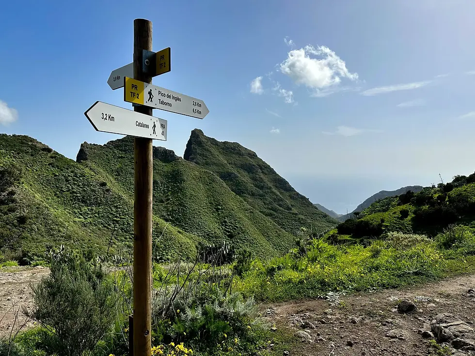


📍Anaga Massif
👣8 km (circular)
🏋️Moderate
⏱️Estimated hiking time: 4 hours
📈Elevation gain: 323 m
⬆️Maximum altitude: 723 m
⬇️Minimum altitude: 443 m
🅿️Parking nearby: Yes
🌥️The route has both shaded and sunny areas.
ℹ️There is no information point nearby.
🗺️This is not an official trail, so access is at your own risk.
⚠️Risks of vertigo and/or falls due to steep inclines, landslides, and abundant vegetation that obstructs the path; wet area.
📸Birdwatching, views, viewpoint, landscape, water galleries.
🌲Mountain area with multiple waterways and abundant vegetation
🏔️ Rural Park declared a Biosphere Reserve by UNESCO in 2015
📋No permits required
The Los Catalanes Trail is one of those routes that showcases the purest essence of the Anaga Massif in northeastern Tenerife. Along its length, visitors traverse landscapes where nature and history intertwine intimately. The trail begins in Las Huertas, a rural enclave filled with old terraces and small houses, and descends to the hamlet of Los Catalanes, one of the most picturesque and best-preserved in the area.
The trail winds along cobbled paths and dirt tracks, skirting ravines and slopes covered in the typical vegetation of the Monteverde forest: heathers, laurels, ferns, and faya trees that retain moisture even during the driest months. As you progress, you'll be rewarded with spectacular views of the Atlantic Ocean and the valleys that plunge steeply to the coast. On clear days, you can also glimpse some of the coastal villages of Anaga, their reddish roofs contrasting with the intense green of the landscape.
The most striking aspect of this route isn't just the views, but the surrounding atmosphere. The silence, broken only by birdsong and the sound of the wind rustling through the leaves, makes each step a relaxing and almost meditative experience. Along the way, you can see ancient stone walls, water channels, and the remains of threshing floors, testament to the agricultural way of life that prevailed for centuries in these isolated hamlets.
This trail has some inclines that require a reasonable level of fitness, especially on the final stretch towards Los Catalanes. In return, the arrival rewards you with an environment that seems frozen in time: traditional Canarian houses, narrow streets, and an air of authenticity that few places retain.
The Los Catalanes trail is ideal for those seeking to discover a less-traveled side of Anaga, steeped in history and with the unspoiled charm of rural life. A hike where landscape and tradition blend in perfect harmony, offering a glimpse into what life was like on the island long before tourism.


Mess conferma
Nome Utente
Testo della recensione
1
Commenti
Mess.conferma
Where to eat
Lucky Helado
If you're in downtown Santa Cruz and fancy something cold while strolling around Plaza de España, Lucky Helado is a very convenient option. It's a takeaway shop with a variety of ice creams and fast service, ideal for a quick stop before continuing your walk. Perfect for cooling off without any hassle right in the city center. There are often queues.
What to see
Presa de los Campitos
If you're looking for a peaceful getaway near Santa Cruz with a unique twist, the Los Campitos Dam has something special. It's not just nature: it's an abandoned structure that lends a distinctive character to the surroundings. You can stroll around, explore, and discover the contrast between the natural landscape and what was left unused. It's a little-known spot, perfect for disconnecting and discovering something different without going too far.
Activities
Área Recreativa Llano Los Viejos
If you're looking for a picnic area within Anaga that's more secluded and less crowded than others, Llano de Los Viejos has a very different feel. Here you're immersed in the laurel forest, with frequent mist, humidity, and that typical silence of the northern mountains. It's a more enclosed spot, perfect for relaxing, having a picnic or barbecue, and disconnecting from the hustle and bustle.
Beaches
Playa de Benijo
Benijo Beach, in northern Tenerife, is one of those places that seem like something out of this world. Wild, dark, and powerful, it combines volcanic sand with a rough sea and the silhouettes of rocks emerging from the Atlantic. It's ideal for those seeking pure nature, far from mass tourism. The sunset here is one of the most impressive on the island: the sun sets behind the rocks while the sea is tinged with gold and violet.
Nightlife
Lone Star
If you love rock, Lone Star isn't just a cocktail bar: it's one of Santa Cruz's most iconic venues for enjoying great music and an alternative atmosphere. Here, guitars take center stage over current trends. Between concerts, DJ sets, beer, and a decor brimming with vinyl records and musical memorabilia, the bar has become a true meeting point for rock lovers of all generations.
Shopping
Vermut el 18 blanco
If you enjoyed the red Vermouth 18, this white one takes a completely different approach. Everything here is fresher, more citrusy, and lighter, but without sacrificing complexity. You'll notice it from the first sip: herbaceous notes, fruit, and that gentle spiciness that makes it so easy to drink. It's perfect as an aperitif or for something more relaxed. Personally, I prefer red vermouths, but when it comes to the 18, I can't decide which one I like best. They're both incredible.
Sports
Santa Cruz Extreme
The Santa Cruz Extreme is an iconic mountain race in Tenerife, which runs through Anaga Rural Park and finishes in Santa Cruz. It has several categories (60 km, 33 km, 18 km, 10 km, and a vertical race), with steep slopes, routes along trails, and traditional farmhouses. Held in October, it attracts runners of many nationalities; it is also notable for its sustainable approach and for promoting the natural and rural value of Anaga.
Trekking
El Tomadero
A circular route in Anaga Rural Park connecting Punta del Hidalgo with El Tomadero, ascending via a channel carved into the rock and descending through the ravine. It's approximately 6 km with little elevation gain, but includes technical and exposed sections that increase the difficulty. The channel is in very good condition and clean, although it can be quite vertigo-inducing in some places. The descent through the ravine is rocky and uncomfortable. A short but demanding route, not recommended for people with vertigo.